


By Kendal Archer
On 28th to 30th September last year (2021), the PACCo team welcomed national expert in marine and freshwater fisheries, Steve Colclough, to the lower Otter site. Along with ten volunteers, we were to spend two days on the estuary monitoring fish fry in the saltmarsh and estuary area. The aim of this monitoring was to establish a baseline for fish populations in the estuary before the planned embankment breach in March 2023 (planned as part of the Lower Otter Restoration Project), which will re-create significant areas of intertidal habitat. It is the hope that with the re-creation of this intertidal habitat, we will see an increase in the number (and possibly species) of fish using the lower Otter estuary as a nursery ground and for feeding and shelter. This is important for wildlife, biodiversity and the socioeconomic fabric of the area.
We know that estuaries are extremely productive environments, playing a crucial part in the life cycle of many fish species. They act as key marine fish nursery grounds, as well as vital corridors for migratory species. These are highly dynamic environments, with abrupt changes in oxygen concentration, temperature, turbidity and salinity applying over both the short term and over longer seasonal cycles (Colclough, 2021). This means that those fish that are able to survive in these conditions are highly dynamic too, being resilient and highly adaptable. The intertidal areas and saltmarsh on the fringes of the estuary are vitally important refuge and feeding habitats for fish fry (Colclough, 2021).
As such, this is an important piece of monitoring to complete as part of the project, to help us understand baseline data for local species. The data collected will feed into our understanding of the environmental risks and benefits of a managed realignment project such as LORP, as well as feeding into the socio-economic assessment being carried out for the local area.
So, on three days in September, we set out to survey the number of fish fry in the lower Otter estuary. On day one, we set out to do a recce of where to lay our nets and allow Steve time to familiarise himself with the site. The tail end of a storm meant that the strong winds and parallel rain chased us off the estuary pretty swiftly, but not before we’d established a few good sites for the different type of netting activities that were planned for the following two days.
On day two, we started the day by completing a two-hour training session ahead of our on-site surveying. This was to equip us with relevant knowledge about the importance of estuarine areas for fish; how fish use the tidal flows to feed in intertidal habitats; and experiences from sampling fish in saltmarshes and managed realignments from across the country. We were briefed on different types of nets and techniques, and so were prepared ahead of an afternoon on the estuary.
Heading down to the site together, the sun had thankfully come out for us. As we had missed the morning high tide for training, we were limited to the type of net we could deploy (seine net only) and the areas where we could survey (the main channel only where water was high enough, rather than some of the smaller channels in the salt marsh further up the estuary). This was a lesson learnt for future surveys, as we would learn to choose our days based on tides and height of water we might expect to see in the estuary.
Importantly too, we had chosen to survey in September as there are only certain times of year where it is possible to carry out these type of fish surveys. Due to the strong seasonal and daily rhythms of our estuaries and the fish that live in them, late Summer and early Autumn is the best time of year to complete this type of survey.
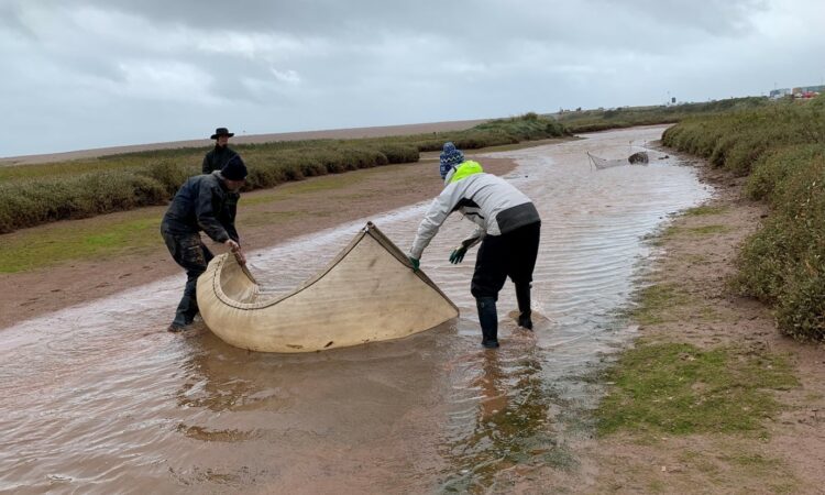
For our first round of surveys, we cast a seine net into to water close to the mouth of the river, where it was deepest (Image 1). Steve led this piece of work, as he had the correct equipment (dry suit) and in accordance with the risk assessments that were in place. We completed two sweeps (at 13:30 and 14:30), capturing 8 thin lipped grey mullet, 12 Bass and Common Gobies (abundant). We also caught shrimp and prawns.
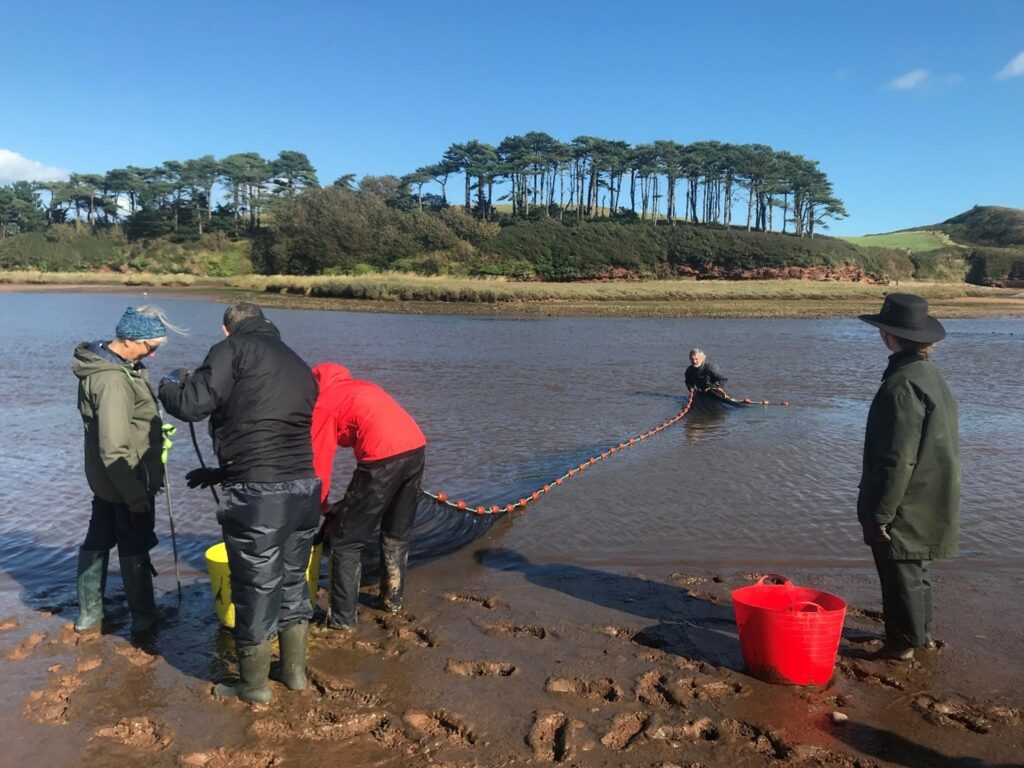
Image 1. Seine netting at the mouth of the river.
This was a great opportunity to practise our identification and measuring skills. As the first seine net was hauled out of the water, we saw hundreds of small fish caught in the large net. We moved these fish swiftly from the net to aerated buckets and trays filled with water. The shallow trays allowed us to examine the fish in order to familiar ourselves with the species. We did not keep them in these trays for too long, instead transferring them to the deeper aerated buckets. From here, we methodically used small nets to fish out the fry; from here they were placed in small plastic measuring brackets (see image 2) so we could record the number of fish we had netted and their length. We also made a note of the water salinity at the point where we had netted the fish. For all deployments across both days, salinity was low. Once all the fish had been measured, we quickly returned them to the estuary. We carried out two sets of seine netting on the first day, before calling it a day.
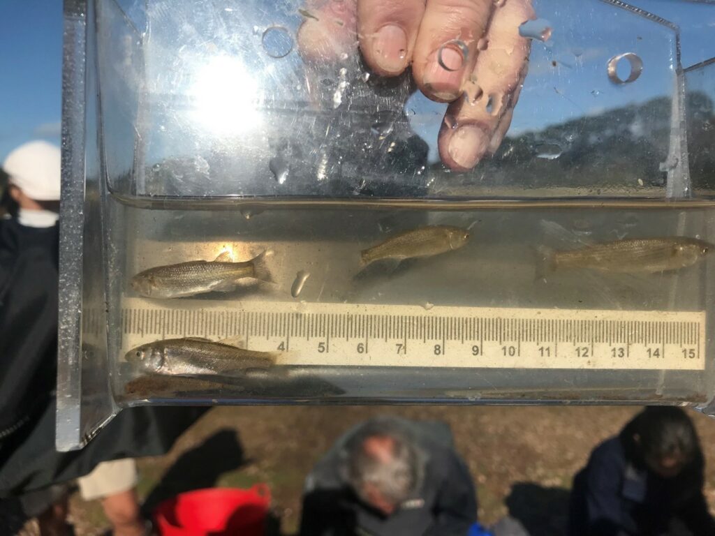
Image 2. Measuring tool for capturing the length of the fish
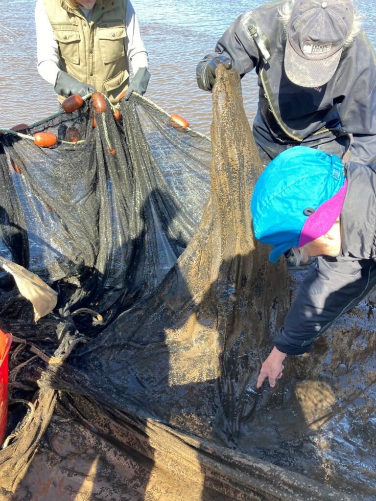
Image 3. Fish caught in the seine net
On the final day of our monitoring, we laid several winged fyke nets across the estuary and saltmarsh areas. See image 4 below. These were deployed with stakes in the morning on the early flooding tide as the sea water enters the estuary. The shape of the fyke nets mean that fish swim past them on their way into the estuary as the sea water enters on the tide; as the fish return later in the day as the tidal water flows out of the estuary, they are gently caught at the bottom of the winged fyke net. The fyke nets were all fitted with otter guards too to ensure no otters could become caught or entangled. We deployed these in four locations across the site, some of which were flooded by the tidal water. The tidal water did not come in far enough to fill two of the nets, but in one of those two fyke nets, we found Bass that must have been sheltering in pools of water in the saltmarsh throughout the day, as they could not have been brought in on the tide. This gave us further insight into the behaviour of fish in saltmarsh and estuaries.
On this final day, we also deployed an intertidal net as the flooding tide began to cover the ground (see image 5). This allowed us to gently trawl one of the smaller channels in-between saltmarsh for fry while we were waiting for the tide to come in and go out, hopefully filling the fyke nets. In this net we caught very small Common Gobies, some as small as the tip of a fingernail, illustrating the value of using multiple sampling techniques.
Finally, the seine net was used again twice in the afternoon in the main channel of the river that was protected from the strong ebb flow. As before, Common Goby were the most abundant species, with many not counted and measured due to their abundance.
Overall, on this second day, we counted and measured 89 Thin lipped great mullet and 8 Bass from the fyke nets and seine netting.
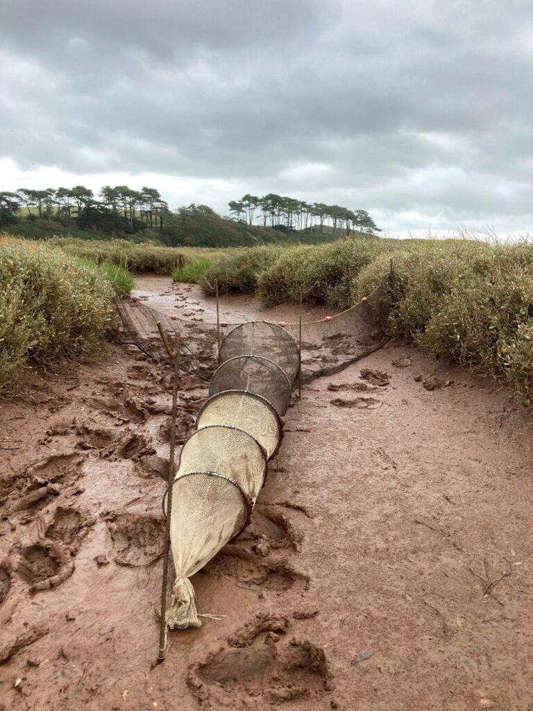
Image 4. Fyke net
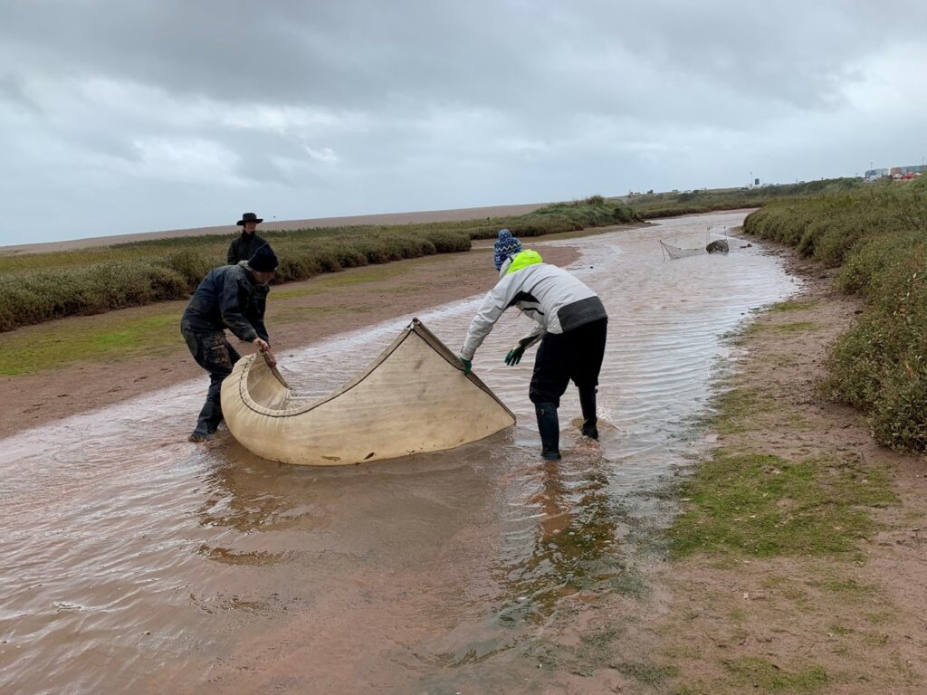
Image 5. Intertidal netting (and partially covered fyke net behind)
We learnt several important lessons from these few days and plan for Steve to return later in 2022 for more monitoring ahead of the embankment breach in 2023. We will also choose days when the tide will reach further into the estuary on high tide. This should make fyke netting more effective and mean a higher percentage of salt water in the catch too.
Steve concluded that, “The fish community described in the Lower Otter estuary and associated saltmarshes is similar to that described in more detail in the Exe estuary, dominated by common goby, bass and grey mullet species. These species have all been regularly reported from estuaries, saltmarshes and managed realignments in England, showing a high degree of penetration and utilisation. It is very likely that these species (and others reported in the Exe) will utilise the new habitats now under construction in the Lower Otter estuary in a similar manner.”
Citizen science also formed an incredibly important part of the monitoring and will continue to do so in the future as we develop our own volunteer led monitoring. Importantly, no boat was or will be required for the type of surveying we have planned, which makes the surveying accessible and more practically achievable. We are already looking forward to the next stage of monitoring and have a huge thank you to say to Steve Colclough, Kate Ponting and all of the brilliant volunteers who involved.