


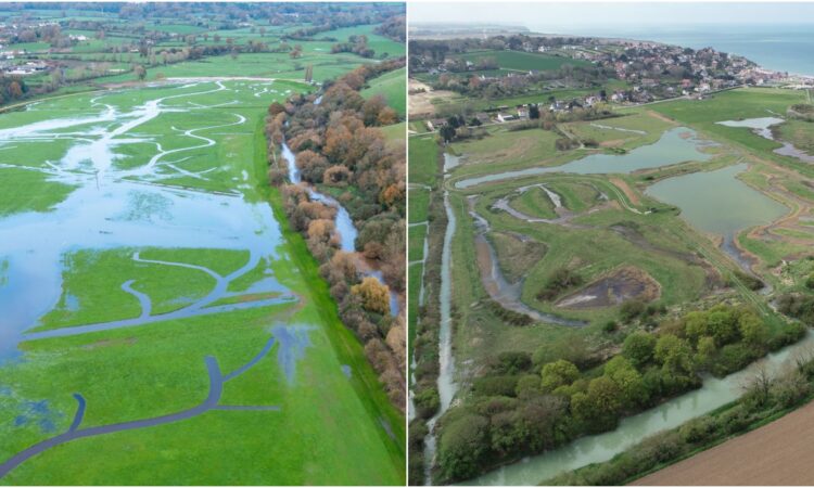
Two mirror stories: the River Otter in Devon and the River Saâne in Normandy were cut off from their natural water courses in the 19th century due to man-made modifications, but soon they will be reunited.
The Otter returns to its original floodplain
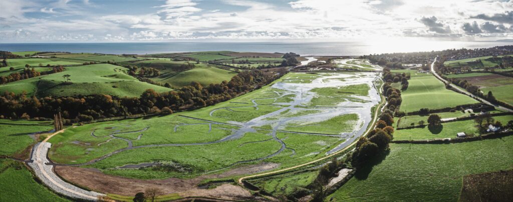
Giving the river access to its natural floodplain again will allow it to spread out and flow naturally in the event of flooding – this is one of the main objectives of the Lower Otter Restoration Project (LORP), the English arm of the PACCo project.
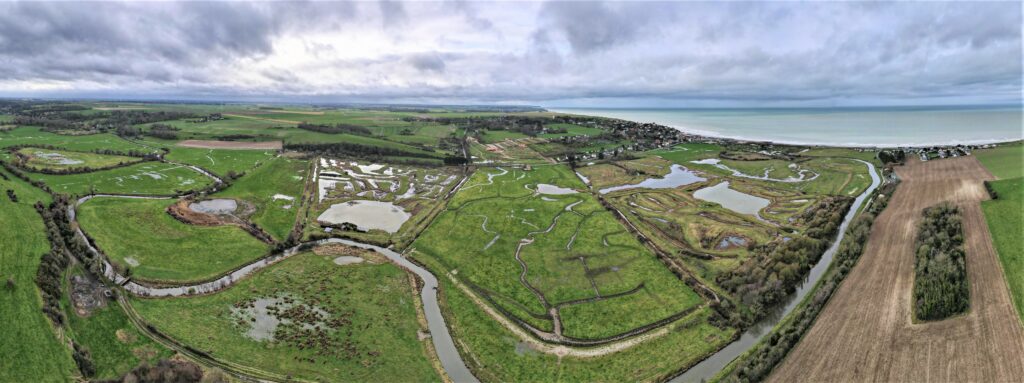
The Lower Otter Valley has been heavily modified by man over the last 200 years with the construction of an embankment, road, landfill, aqueduct, cricket pitch, car park and former railway line. These structures are difficult, and expensive, to maintain and hinder natural processes, including water movement, which affects habitat quality and diversity. Since the creation of a dyke in the early 19th century, the River Otter has been disconnected from much of its floodplain.
The water flow of the river has changed, and today all of the surrounding infrastructure, which constrains the Otter into a small part of its original floodplain, constitutes a risk rather than protection. It has therefore become urgent to adapt the area to rising sea levels and a changing climate, and allow the river to reconnect through a breach and new, more natural channels.
It would be easy to say let’s just destroy the dykes completely, but this was not chosen as an option as many sections are used as public footpaths, and certain activities located in the original floodplain need to remain dry. There is only one solution that benefits the river, wildlife, environment and local communities in tandem, and that is to breach the dykes at several coordinated points.
Simple, isn’t it? No! The main earthen dyke is used as a hiking trail and is part of the South West Coast Path, an extremely popular national trail that cannot be closed. It is therefore necessary to build a 70-metre long footbridge to ensure the continuity of the path by spanning the gap, reducing its flood risk, and allowing walkers to pass over the floodplain
Similarly, to ensure safe, flood-free access for residents and businesses to certain parts of the area, the road that serves them needed to be raised, and a 30-meter span road bridge built.
In addition, a former landfill site, which is currently located in the floodplain and poses an environmental risk, needs to be contained. Work will be carried out to protect it from erosion and its cover will be increased. A sewage pipe that runs along the landward side of the shingle spit (Jurassic Coast World Heritage Site) is also being replaced by a new pipe under the estuary. This will allow natural erosion and deposition to occur and reduce the risk of pollution.
Another important pat of the project works is the removal of the old and unsightly concrete aqueduct on stilts carrying Budleigh Brook. The brook has now been returned to a more natural course through a newly created creek network. This is particularly beneficial to wildlife, such as wading birds and invertebrates, and provides easier passage for fish.
Last but not least, the much-loved Budleigh Salterton Cricket Club has been relocated to a new site outside of the floodplain to ensure that the seasonal flooding it was subject to in the past stays a thing of the past. The new site will provide even more facilities and allow the club to expand. After all, this is England, and by Jove, we don’t mess around when it comes to cricket!
Of course, all of this work is expensive, but the benefits are not limited to flood resilience. By breaching the dyke, more of the historic floodplain is allowed to flood at high tide and flow at low tide, producing important intertidal habitat, mudflats and salt meadows for wading birds. Areas of reedbeds and grazing marshes will also appear over time.
The Saâne returns to the sea
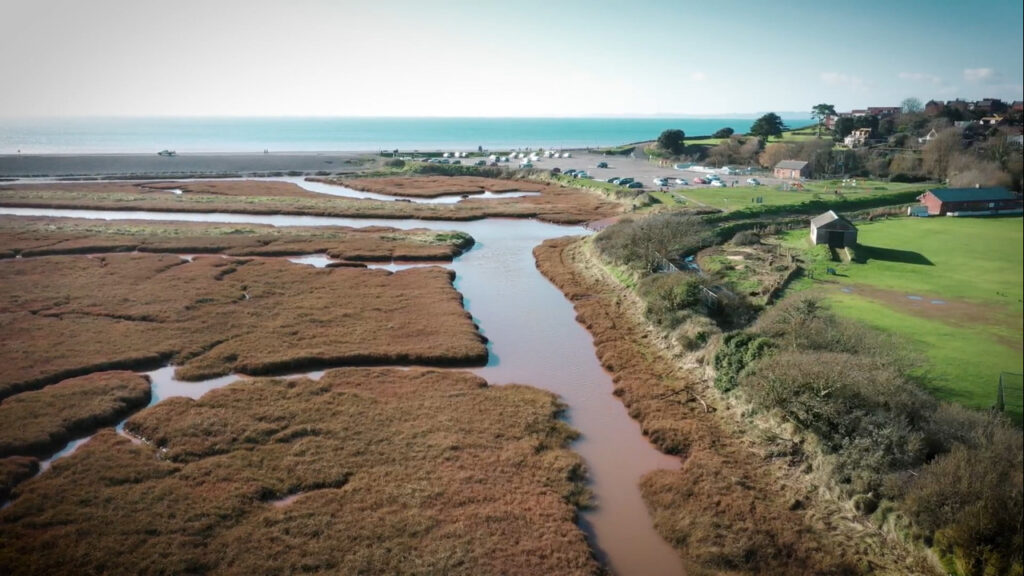
Everyone knows the history. In the past, the sea penetrated the Lower Saâne Valley at every tide, and went as far as Longueil (where there was a port, rue des pescheries!). At the end of the 19th century, the construction of the Quiberville-Sainte Marguerite dyke made it possible to “polderise” the lower valley, to prevent the sea from entering, and to develop agricultural and tourist activities on the land thus gained, including the Quiberville campsite. At the same time, the merlons (embankments) built on the banks of the river enabled the river to be channelled and protected the land reclaimed from the sea from flooding.
However, from the end of the 20th century, the inconveniences began to outweigh the benefits of these facilities. The first warnings came in 1977, 1978 and 1984 when storms damaged the dyke and caused flooding, the rate of which accelerated in the following years (1990s and 2000s).
It was clear that the disconnection between the river and the sea, which the dyke had created, had reached its limits. The dyke helps to protect the lower valley from marine submersion, but it is not adapted to strong storms. On these occasions, the sea submerges the dyke and contributes to its degradation. In the case of floods caused by the River Saâne, the dyke and the culvert prevent the water from flowing into the sea and exacerbate flooding. Climate change is now increasing the frequency and extent of both phenomena. In particular, the rise in sea level and the increase in the frequency and severity of storms mean that the valley’s territory must be adapted to shifting climate conditions.
But creating a new connection means recomposing the entire territory of the lower valley. The first step was to partially recover the original floodplain by moving the infrastructure that had been installed there, primarily the Quiberville campsite and the Sainte-Marguerite bungalows.
On the site of the old campsite, a new meander in the river will be created. The second step: to give the Saâne back access to its original floodplain, by removing the merlons that channel it. And the final step: to properly link the sea to the river. Not by a tiny culvert as is the case today, but by a bridge under which the Saâne will flow and over which the coastal road will pass.
The new connection between the river and the sea will encourage salt water intrusion during high tides. The area around the re-meandered Saâne will regain an estuarine function, with the restoration of wetlands favourable to biodiversity. It will allow the development of new agricultural practices, and will offer the inhabitants of the valley and visitors discovery routes.
In the river thus reconnected to the sea, many species will be able to find a habitat they can thrive in. For example, the eel, which will be able to swim up the river to prosper in peace, or the sea bass, which can sometimes be seen near the nozzle, clumsily trying to cross the obstacle… and often failing. Without the culvert, the river and brackish waters is theirs once again to frolic and enjoy!